Custom Sales and Territory Map Creation with GB Maps!

Create gorgeous territory maps, sales maps, population maps, heatmaps and more with the gbmaps map colouring system.

  • Dozens of boundary maps
  • Healthcare, Governmental and International maps
  • Intelligent Analytical Tools
  • Total Interactivity for All users
Try the DEMO Tool Now
usa map colouring tool


MapofZipCodes Client list

Advanced Mapping Tool Features

High-Quality Boundary Maps with a Choice of Backgrounds

Our advanced interactive mapping tool offers high-quality boundary maps, tailored to meet various specific needs. Our detailed resources encompass postcode districts, sectors, and areas, facilitating precise regional navigation. We also provide extensive mapping data for councils and counties, ensuring effective local governance planning. In the healthcare sector, our service is vital; we offer comprehensive NHS maps, showcasing healthcare facilities and resources for enhanced decision-making. Whether it's for meticulous logistical planning or strategic infrastructure development, our mapping tool is your reliable companion, integrating diverse geographical data in one easy-to-use, interactive platform.

We're introducing an intelligent postcode search feature designed to streamline your company sales and quoting. By inputting a postcode, users can swiftly access corresponding markers, shapes or drivetime polygons relevant to that area. This includes identifying the nearest marker – be it a sales-person, delivery driver or customer – thus offering valuable insight at a glance. Moreover, this function provides the name of the coloured area associated with the given postcode, ensuring users can quickly contextualize their search within broader geographical structures. This intelligent postcode search feature adds depth to your exploration and eases your quest for pertinent regional information.

Concentric & Individual Drive-time Polygons

Our cutting-edge interactive mapping tool further enhances your experience with an innovative isochrone feature, also known as drivetime polygons. By setting a specific amount of time/distance, users can instantly visualize how far they can drive in any direction from a given point. This concentric and individual-based utility generates an intuitive display of reachable areas within the specified timeframe. It's an invaluable resource for businesses; whether you're calculating delivery costs based on distance or designing efficient sales territories, our isochrone feature provides the clarity you need. With this tool at your disposal, strategic decision-making becomes a seamless process.

Population and Other Census Figures

Another exceptional feature of our advanced interactive mapping tool is the integration of population and census figures. This feature allows users to overlay demographic data onto their maps. Depending on the areas you have highlighted or coloured, you can add corresponding population figures to both the map and key. This provides a vivid illustration of population compared to your map data, whether it's a heatmap of your locations, customers or something else.

Usage Statistics and Analytics

Our interactive mapping tool is designed for optimal collaboration. Users can readily share a link to their personalized map with colleagues or customers. While these shared links maintain the visual data, they conveniently hide admin features to maintain the map's integrity. Moreover, we have incorporated tracking capabilities that monitor how these shared maps are utilized. Back in the admin area, users can access detailed analytics - from how often the map page has been loaded, to which postcodes have been searched for the most. This seamless sharing and tracking feature boosts engagement, collaboration, and insights, catering to your ever-evolving mapping needs.

Planned Mapping Features to Expect in 2023

Route Optimisation

You can already add thousands of markers to your map. You will be able to select or list your locations, click go and receive a fully optimised route around all your locations. Multiple delivery drivers, shifts, breaks are all possible. You'll also be able to create detailed standard routes. These routes will come with accurate drive times and distances so you can plan your day accurately.

Postcodes Within Areas

In many situations it's important that you have an accurate list of postcodes for a specific area. This could be for advertising, deliveries or sales areas. The UK now has over 1.7 million active postcodes and it's often just too difficult to create an accurate
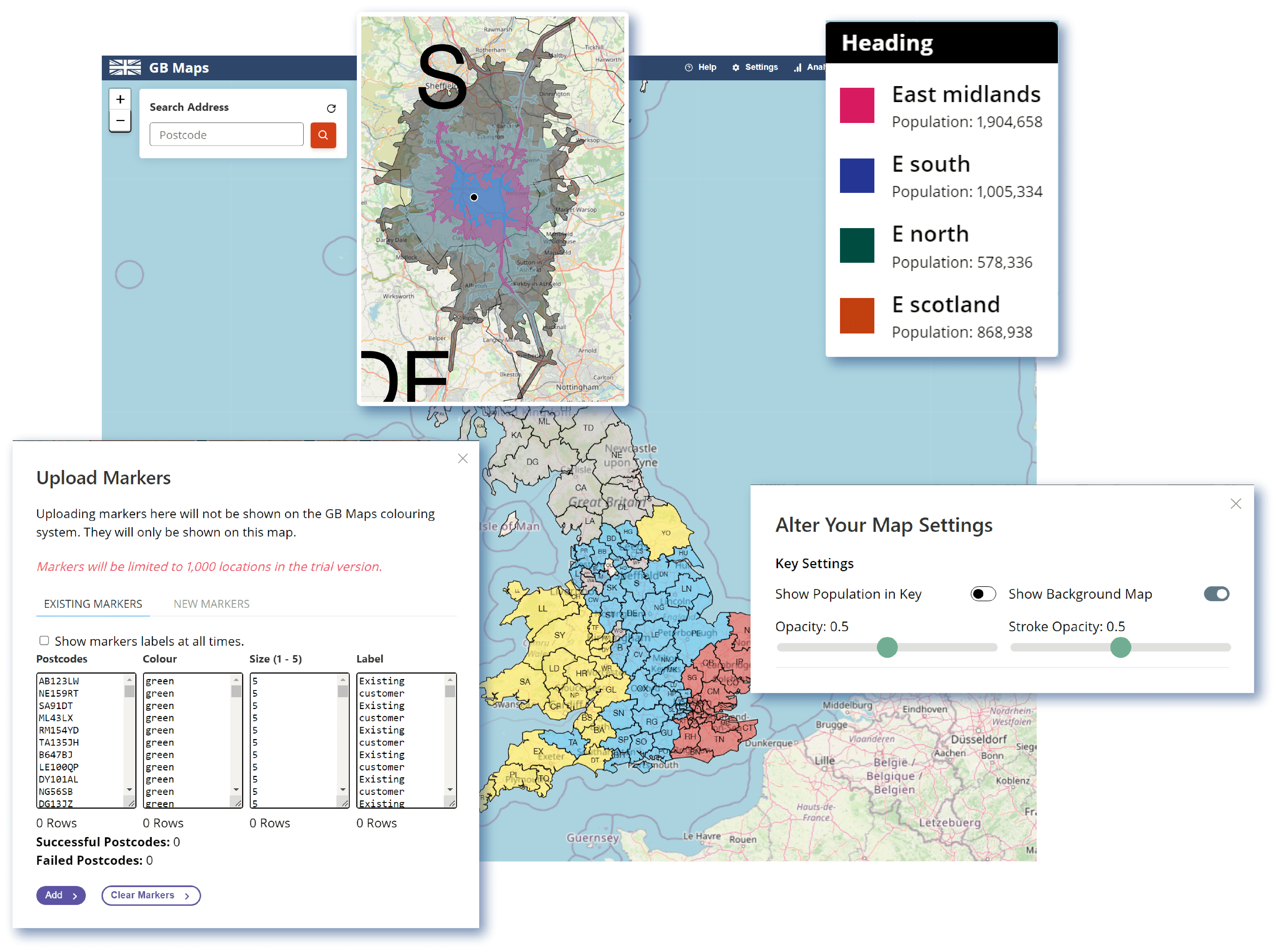
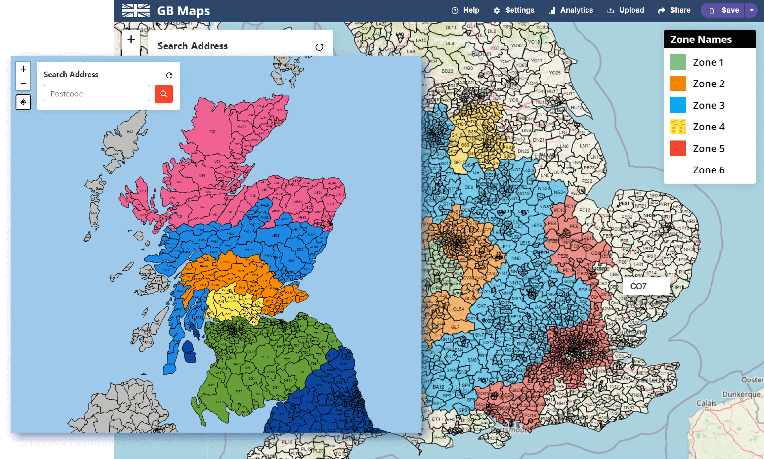
Overlay Extra Maps

We have over a dozen basemaps to colour and use on our tools. Our plan is to release a feature to show or hide extra maps on top of your basemap. This is a popular request for NHS maps, allowing the user to quickly see how different boundaries relate to each other.

An All Round Mapping Tool

Food Delivery Company

Many delivery companies benefit from using our mapping tools. As an example we have described how the features on our tool would allow a food delivery company to optimize their operations.


Identifying New Areas with Population Data

We have lots of figures for many different demographics on loads of our maps. A delivery company creating a map can use the hover setting to see a chosen demographic when hovering or clicking on an area. If you have a target customer you can create zones with similar populations of that type of person.

Optimizing Delivery Pricing with Concentric Drivetime Polygons

Drivetime polygons (isochrones) area intricate polygons that show how far you can drive in a certain amount of time from a specific location. Using our concentric isochrone tool, you can create delivery zones that are accurate to the time it takes to drive them. Simple circles are very inaccurate when comparing a motorway and village road.

Quickly Price Deliveries with the Intelligent Postcode Search

You can use our postcode search feature to quickly identify which zone a customer is located. When on the phone with a customer it's hard to quickly calculate delivery to their location. Our postcode search will show which boundary, circle or polygon they are located and output the corresponding price.

Select your Mapping Plan

Get in Touch

We're happy to help with any questions or requests you have. Feel free to get in touch at any time.

Frequently Asked Questions

Read through our FAQ's page. We've answered a lot of mapping questions.

About Us

Learn more about the history of gbmaps.com and this tool.